
Community Profiles
Findlay Township
The largest Township in Allegheny County, was once part of “Moon”. In 1819, a petition was presented to create a “Second Moon”. On February 21, 1822, boundaries were confirmed and the name chosen was “Findley” ( later changed to “Findlay”) in honor of Governor William Findlay. Findlay had a total area of 32.6 square miles. At one time, Robinson Township in Washington County, and parts of Hanover and Independence Township in Beaver County were considered part of the Township.
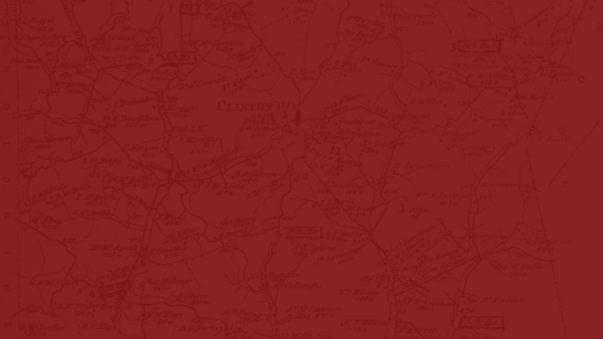
Isaac Charles was given 10,000 acres of land by the King of England, for his part in the French and Indian War, in the Clinton area. He gave away some of his land to entice settlers to the wilderness that was plagued with frequent raids by the Iroquois Indians. Cabins were burned and settlers were killed, but the settlers were determined and returned to rebuild. In 1826 the Village of Clinton (originally “Corners”) was laid out and named after the famous foxhound and the story that accompanied it. Natural gas and oil were discovered and many men left the farms to work in the newly developed areas of coal, gas and oil. Other areas of Clinton, Cork, Virsiox, and Clinton Block developed.
The Pittsburgh Coal seam is found throughout the area at elevations of 1,100 to 1,200 feet. With access to the “black diamonds”, the Township has been extensively deep and strip mined. With the arrival of the Imperial Coal Company and the incorporation of the Montour Railroad in 1877, the Town of Imperial (originally called Montour City) was established in 1878 with the Coal Company owning the majority of the houses and stores.
Areas of Imperial were developed such as Buttermilk Row, Big Bug Row, The Patch, Cliff Mine, McMinn became known as Enlow after the railroad stop, Enlow Station, Jeffreytown, Turtletown, California Hollow, Jug Hollow, Whiskey Avenue, Boggs and Slabtown.
Grist mills, run by horse-power, once stood on the Montour Run, Potato Garden Run and Raccoon Creek.
In pioneer days Conestoga wagons were used for hauling goods. One of the wagons, owned by John Swearingen, is in the Carnegie Museum in Pittsburgh.
The township remains a scenic region of forested slopes and combines the tranquility of open space, farmland, residential and commercial areas, along with being the Home of the Pittsburgh International Airport with major highway access by way of Route 376, Route 30 and the Findlay Connector (576).
North Fayette Township
Just as Findlay became a subdivision of Moon in March of 1790, so did another portion - Fayette, named after General LaFayette, became four separate entities – North Fayette, South Fayette, Robinson and Collier. In 1801, Robinson Township was created from the territory of Fayette. From 1809-1811, attempts were made in the Court of Quarter Sessions to further subdivide Fayette. In a reference from “History of Allegheny County” published by L.H. Everts & Co. in 1876, serious discussion on the subdivision referenced in 1840 and on March 16, 1846, North Fayette finally became an entity of it’ own. An article published in “The Oakdale Beacon” in 1893 indicated that a project to further subdivide North Fayette into a Northside and a Southside was abandoned.
North Fayette is a township dotted with history. As the former Fayette Township, it was noted for more Indian outrages than any other township in the county. The Mingo Trail traversed what is now the road from Noblestown to Beaver Falls. Many scalping episodes occurred along the trail.
Before its formal designation as a township, records show that a stockade was built on the land of William Turner, an early settler who took residence in the area around 1774. Called Fort Turner, it was built around 1778 off Route 978 between Routes 22-30 and North Branch Road where the former villages of Shirland and Fayetteville once stood. The fort was built as a protection against the Indians. Charles Lutz later owned the land, on which the fort was built, according to a report prepared by John Scott in 1932. Scott also notes that the fort was a well-built blockhouse surrounded by a stockade which enclosed a never-failing spring. The last known Indian outrage affecting the people of the area occurred about 1780. William Turner, his family and a friend traveled to Beaver County in the spring to make maple sugar. While there, the Indians killed Turner and his friend, taking others captive.
Those who settled in the North Fayette region found its terrain and fertile limestone soil produced fine crops. The area, which also traversed a portion of Imperial, was rich in petroleum, natural gas and coal. North Fayette was also one of the richest regions of bituminous coal at one time.
The Montour, Dickson, Santiago and Cliff Mines operated in North Fayette, with the majority of the coal being extracted primarily along the Montour Railroad line While the Montour Railroad was located at the northern end of North Fayette in Imperial, the old Pan Handle Railroad, later known as the Penn Central Railroad, was built in 1868 and traversed the eastern boundary near Oakdale. Railroads were one form of transportation.
The historic Pittsburgh Steubenville Turnpike crossed the township from the northeast to the southwest and was traveled between Pittsburgh, Steubenville and points west.
Numerous hostelries were established as shopping places along route such as this and Route 30 to East Liverpool. One of the most noted is the historic Glen Gormley, built in 1852 by Andrew Pierce as a stagecoach stop. This was reportedly an Underground Railroad stop during the Civil War. His son later converted the building into a cancer and tuberculosis hospital.
Noblestown, once known as Noblesburg, was one of the oldest towns in this area of Allegheny County. The town was established in 1773 and derived its name from Colonel Henry Noble, who built one of the first flour mills in the township dating before 1800. Other names either in or surrounding North Fayette has derivatives. They include Montour Run (named from an Indian of three-quarter blood called Henry Montour), Enlow from the old Enlow family, and Sturgeon from Henry Sturgeon. Other small villages in the township have brief but historic significance. North Star was chosen as the name of a stop on the Montour Railroad (also the area in which the old North Star Hotel on Steubenville Pike stands), and Santiago (Tyre) was named such by its residents during the Battle of Santiago of the Spanish-American War of 1898.
Oakdale Borough
The land on which Oakdale is situated (except Highland Avenue) was originally part of a 400-acre tract of land which the Commonwealth of Pennsylvania granted to Judge Hugh Henry Brackenridge on April 11, 1778. In the original warrant, the name given to this land is called Mt. Helicon, a name from Greek mythology, the sacred home of the Muses. For a time, Brackenridge and his family lived in the area but in the late 1700’s, homes this far from Pittsburgh were the exception, not the rule. Population was scarce. Raids by hostile Indians were a threat and would continue to be so for a dozen years. Survival was a struggle. In August of 1801, Judge Brackenridge sold his 400 acres of land to Henry Sturgeon for $1,200. Farming was the predominant activity for the next 50 years. The land that Henry Sturgeon purchased became farms bearing the names of Hastings, Kennedy, Sturgeon, Kemp, McGill and Gamble. Later, the list of farms would include the names McCandless, Whitmore and Love. Robinson Run Creek formed the boundary between North Fayette and South Fayette Townships. Farmers found the gently sloping hills above the town suitable and soon enough a mill was constructed on a point of land near the Robinson Run Creek. Following the Civil War, the Panhandle Railroad cut a path through the quietly emerging community and things would never be the same as travelers from Pittsburgh to Steubenville could now stop off at “Oakdale Station”.
Outsiders began to see possibility in the sleepy little village. Charles Hanson Love, a dry goods merchant and land developer from Pittsburgh, purchased the farms and began subdividing it into residential lots for grand home along wide Oak lined avenues. Businesses, churches and a school followed and in 1892 it had become obvious that the town must break away from the townships and become an independent political entity. After taking the necessary steps, an order was secured from the courts granting a Charter of Incorporation to the community.
With the pleasant valley surrounded by the impressive oaks on the hillside, the towns name became “Oakdale”.
With the start of the 20th Century, residents of Oakdale encountered their first taste of disaster as the waters of the Robinson Run Creek flooded the community. Such flooding would become a fairly regular occurrence that would plague the population for generations to come. With the advent of World War I, the town stepped into service as the Aetna Chemical Company began manufacturing explosives for the war effort just south of town. A devastating explosions and fire at the plant in 1918 claimed more than 200 lives and thrust Oakdale into national headlines. On several more occasions, in times of war, Oakdale would serve the nation again as her sons and daughters came to the call of their country.
After the war, Oakdale settled into the prosperity of the decade that followed. Businesses were thriving, and families found Oakdale a suitable place to call home. Several generations of students attended Oakdale High School on Highland Avenue until the formation of the West Allegheny School District which would serve Findlay and North Fayette Townships as well as Oakdale.
Within time, outside competition from larger businesses would chip away at the local economy as the town would settle into existence as the quiet community we know today. Over the years, the American small town has changed and Oakdale is no exception to that. What is exceptional about Oakdale is the people, namely their ability to roll up their sleeves, look ahead and move forward when challenges come their way.